
We’ve been walking in the Rothbury area for many years. It is beautiful and, even very close to Rothbury, there are plenty of very varied routes. So, for this one, we tried to take the best of all the routes, but avoiding the most challenging paths.
I think we achieved that, and the weather just added to the joy of the walk. Everything was perfect.
The start – Rothbury
We all met in the Haugh Car Park. After everyone arrived, we did the traditional warm up. Another walking group complemented us on our professionalism. They hadn’t warmed up.
The first steps are to cross the bridge. A pleasure in itself. The first real view of the River Coquet is walking over it. We continued along the riverside path, avoiding the multitudes of people arriving in Rothbury. It would get much quieter as we went on.

Close to where we cross the Coquet, for the second time, we followed the right of way across a field. There’s usually a sign warning of a bull in the field (not that I’ve ever seen one there), but that was gone and the path is used more now.

Lady’s Bridge
After crossing the field, we arrived at Lady’s Bridge. You could be forgiven for thinking it has been here for quite some time, but this bridge has only been here since 1968. Ok, that’s 52 years, and might be a long time for some. At the far end of the bridge, there is a gate, to stop any grazing sheep in the next field from wandering over.

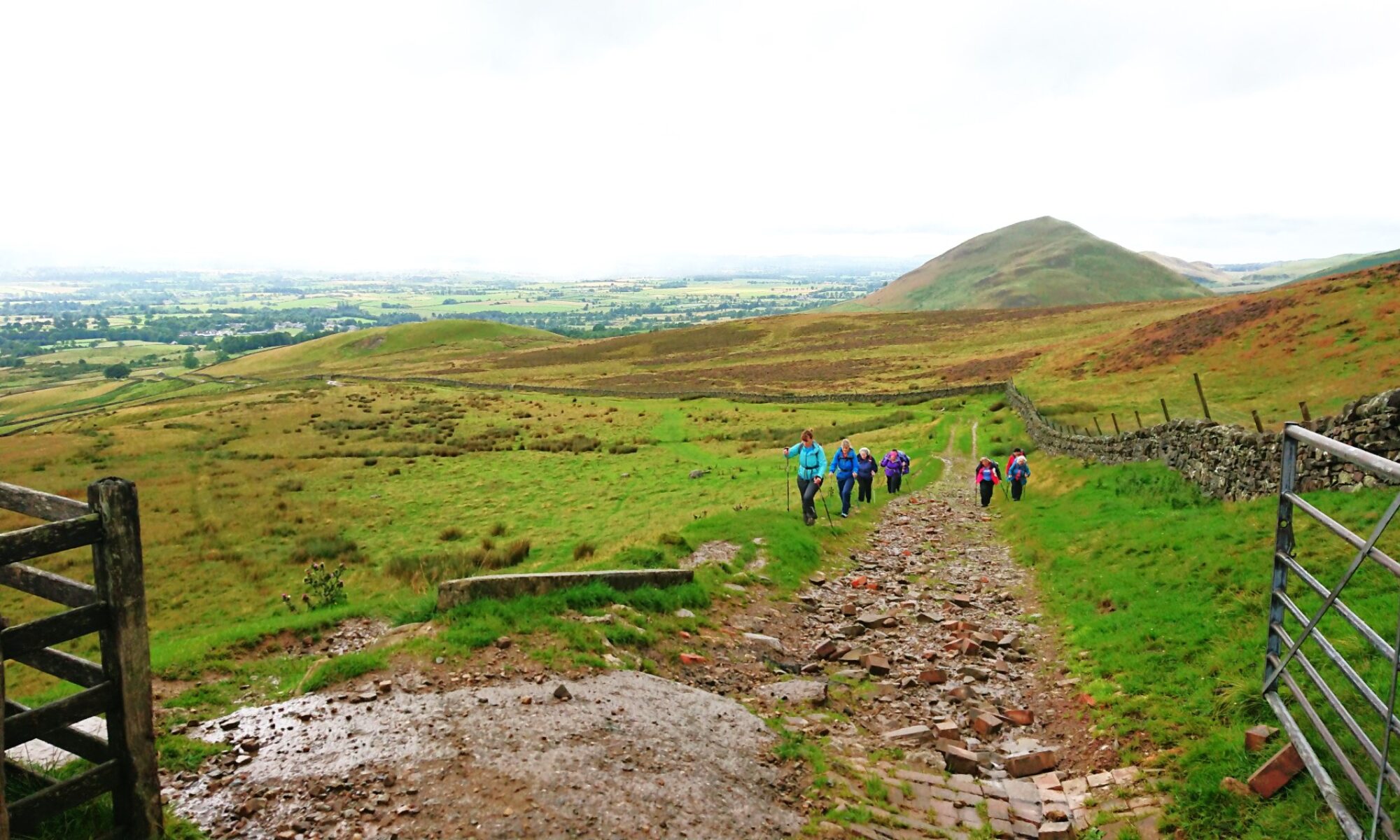
We continued along an old track, at the edge of the next field. This turns into a road that heads to a small hamlet called Newtown. Newtown was new once. Around 1249 actually. Instead of going through Newtown, we took the road up to Great Tosson.
We stopped to admire the view halfway up, because the road steepens as you get nearer the top. What a view!

Great Tosson
Everyone got to the top and remarked that they had never been here before. There was surprise that there was a tower here, Tosson Tower. Although, some who climbed over the wall and walked across the field to the tower took a quick look, returned and pronounced that it was not worth it. Well, the remains of a 14th century bastle tower, built and highly fortified to keep border reivers out won’t impress everyone.

One thing that was of interest was the hay rake shaped like a bird. Chris decided to feed it.

Lunch at the Lime Kiln
Leaving Great Tosson, we walked down the road to Tosson Lime Kiln. On the way, several of us remarked on what amazing views there are from the holiday cottages here.
There are picnic tables at the kiln site. So, even though it was a little early for lunch, it was the right place. It is a beautiful spot, below Tosson Hill and the view from the top of the Lime Kiln is a panoramic vista across the Coquet valley, from Rothbury in the east to Hepple in the west and out to the Cheviot range.

After lunch, we wandered down the road and through a gate into a field. The right of way crosses some fields on the way to the river before crossing a bridge to Thropton.
Thropton
Thropton is the next largest settlement in the Coquet valley, after Rothbury. It is at the place where the Wreigh Burn joins the Coquet. Wreighburn House still sits to the east side of the burn and is said to be built on the foundations of a hospital of the Knights Hospitallers of St John of Jerusalem. It was likely to be more of an inn ran by monks than a modern hospital. Nevertheless, it is likely that the monks gathered herbs and wild plants from the area now known as Physic Lane. This is where we headed next.

Physic Lane
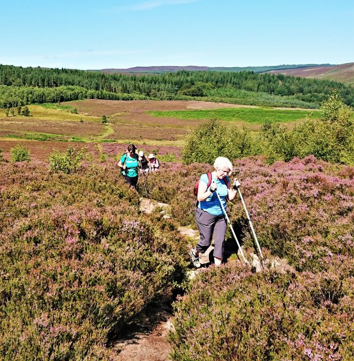
I think everyone had been looking forward to this bit all day. Physic Lane is a lovely hill. All the walkers like a hill. Maybe not.
The good thing about this one is the views up the Coquet valley. We admired the views several times on the way up.

One of our eagle-eyed walkers spotted a dragonfly. We don’t have any dragonfly experts but I got a photo and later examination identified it as a Southern Hawker. As its name suggests, it is not as common in the North, so great to see it.

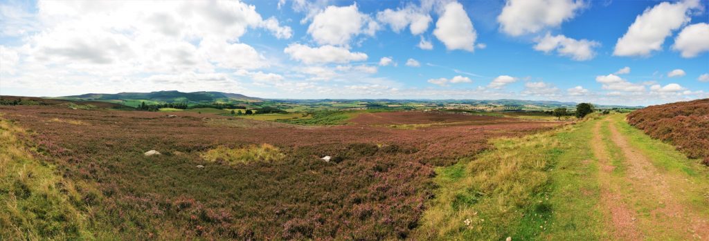
The last stretch of Physic Lane is moorland and gorgeous moorland at that. It leads up to the open moor above Rothbury and onto the Carriageway.

The Carriageway
Lord Armstrong of Cragside created the Carriageway, to take important people out for a carriage ride. I’m sure that they would’ve been even more impressed than us with the views.
A little further round the north side of the Carraigeway, Martin pointed out some zig-zag features in the land. These obviously aren’t natural. In fact, these patterns in the land are the remains of WWI practice trenches. Soldiers were trained how to dig trenches, before going to war. They are over 100 years old now.

The Carriageway carries on east, before turning south. We then entered some woods before heading out to another bit of open moorland.
Some were asking how far we had walked. Some were saying that this was further than 7 miles. Martin agreed. This walk was much longer, nearer to 9 or 10 miles. Which was alright, apart from the fact that it was advertised as 7 miles. Oh dear. No matter, everyone was still enjoying themselves and they were getting a few more miles gratis.
Addyheugh and Addycombe
Eventually, we reached the entrance to Addycombe woods. This offered welcome shade and, at Addyheugh, one of the best view in the valley. The rock in the picture below has many names carved into it. Some dating to the late 19th century. It’s obviously been a popular spot for many years.

We headed off and those at the front stopped to look at mushrooms. At this point, we realised that the back half of the group was missing. We waited, and about 5 minutes later they came proudly round the corner pronouncing that they had seen an adder. Good for them. Here are some photos of it.


As we came out of the woods, we found some highland cattle (I think) with calves. They were beautiful and very calm. They are obviously used to people looking at them.

Back to Rothbury
Just a couple more fields, a road and a track and we were back into the centre of Rothbury. Unfortunately, the butchers had closed at 3pm, so no pies or sausages. We did visit the kiosk at Tomlinsons though, which recently reopened, and bought some cake and drinks to eat by the river.
After refreshments, we headed back to the car park for a cool down, before saying goodbyes.
Hope everyone enjoyed the walk, even though it was 2.5 miles longer than advertised, and saw something that they’ve never seen before.
Julie and Martin x
If you enjoyed the Around Rothbury walk, why not take a look at our other walks.
Gallery – Around Rothbury


Home | Blog | Walks | Sign-up | Contact
Strolls with Poles – Nordic Walking for Fun and Fitness